
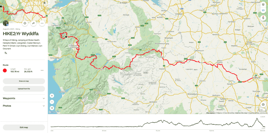
The title does say a lot.
Planning out a route for a nine day hike, having a starting point in Staffordshire and wanting to finish on the highest mountain in Wales. Isn’t an exactly easy task. It isn’t exactly a route that has been walked a lot of times.
Version one of a route from Stafford to Snowdon
I got to drawing out a full route straight away, just knowing a few of the places I would hit trying to go in a straight line.
The map above came out to be a pretty good distance, although it did have a few gaps. Finding campsites along this path wasn’t too easy. As much as there was some locations I would have been happy to just throw a tent up whilst in the Welsh mountains, I didn’t really fancy doing that along a canal path.
At this stage I did think that over half of my nights would be spent camping a little more off grid. As I came to think more about it, I had already realised that these were going to be long days and the very last thing I would want it to be moved on.
Another problem with the route was roads. There wasn’t many stretches, but after a bit of reconnaissance I discovered that I didn’t really want to wondering on the slim and curvy roads of the Welsh country side.
Version two of a route from Stafford to Snowdon
I drew out each day individually.
On paper this looks like a pretty good route, the first three flat days are relatively unchanged, but a couple of the “campsites” aren’t actually for people who own their own tents. So in my mind that means they’re are not a campsite, and that maybe they should change their name!!
After checking some of the paths out, I realised that I needed to look at a route that was a little more travelled. So then I tried to include a few of the National Trails that can be found in Wales.
Version Three of a route from Stafford to Snowdon
This looks like the final route.
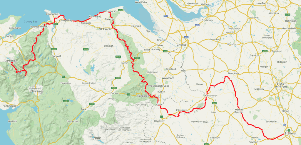
My first three days have changed slightly. The route through Wales though, well that is completely different!
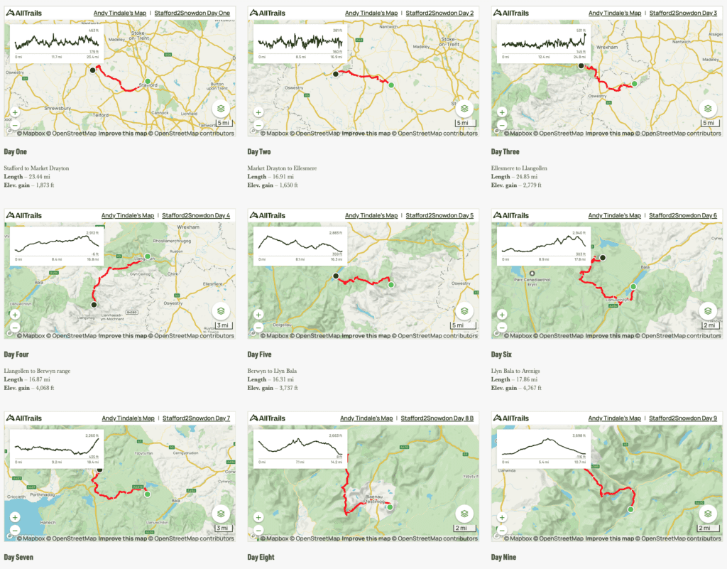
Day One
From Stafford I will be following the Isabel Trail and the the Stafford to Newport Greenway. A foot path that runs along the old trail of a train that many years ago ran through Stafford. For me this is a great place to start, it was the route I started to walk often along when I first decided I needed to seriously take some responsibility for my own fitness.
This will take me to Gnosal where I will join the Shropshire Union Canal and follow this north north west. Basically until I reach a campsite. The first day is going to be a long one, covering almost thirty miles. Due to the nature of the canal path though, it is pretty flat.
Day Two & Three
I’ll start day two by skipping across to the Llangollen Canal. This is going to be my focus for the next couple of days as I follow this through Whitchurch, Ellesmere, Chirk – over the Pontcysyllte Aqueduct – and into Llangollen.
Day Four & Five
Once I leave Llangollen I’ll follow Offas Dyke. This is where the real changes come in from my originally planned route. Heading northwest instead of the initial plan to go south west towards the Berwyn Range.
Now I’ll be covering the entire length of the Dee Valley and Clwydian Range Area of Outstanding Natural Beauty, or National Landscape as they are now known. Which will be two days before I reach to North Wales Coastal Path.
Day Six
I’ll follow the North Wales Coastal Path for the longest, but also the flattest, day of the whole challenge. It’s also the case that the wind probably won’t be my friend. If you are a godly person praying for some still skies and a gentle cool breeze on nineteenth day of June that would be great!
This is going to be one of the hardest days, but it is also passing through many seaside towns, so it will most likely be the day that I stop a little more. I’m going to get a lot of chances to refuel, and top up so that I am full of beans to take on the last three mountain days. During my preparation for this challenge I’m eating pretty healthy meals but during the trek I’ll just be cramming in some calories, so I’m hoping for some seaside treats like fish and chips and maybe a few 99s along the way.
Day Seven
I’ll be heading south from the Coastal Path crossing Carneddau range. I won’t be hitting all the 3000s along the way but still some are going to need to be climbed.
This is the hardest day. It’ll be shorter than the six days that have come before it and I have options for different paths through. Either entering the range from the Tal Y Fan direction or by passing Aber falls further west. Both routes are about the same in terms of elevation gain, but the falls route is a little longer with a flatter stretch.
Day Eight
This should be my easiest day, I have got so many options of paths to take to cross over the Glyderau range. They all come out at a similar length and elevation gain, but some have some steeper sections.
I’ll then follow the path down from Glyde Fawr and end the day on the campsite by Llyn Gwynant.
Day Nine
From Llyn Gywant I will follow the gentle path around to the start of the Pyg Track.
This will be the final ascent of the challenge, reaching the summit of Snowdon before the last few miles down into Llanberis
Distance
It’s a long old hike.
The longest days are the flattest, with day one and day six both coming up close to the 30 mile mark. This is contrasting with the “shorter” mountain days, with a very short day eight crossing over the Glyderau range.
Elevation Gain
The distance alone would be enough of a challenge, the thing that is making this for me though is the combined elevation. Even if I do shorten any days, I will be climbing more feet than it would take to reach the summit of the planets highest mountain.
Support Stafford2Snowdon
I am taking on this challenge in order to raise some funds and awareness for our mental health services with all funds raised going directly to Mind Charity.
Any donation would be amazing, this isn’t for me it’s to help support the millions of people everyday who need help from our mental health services.